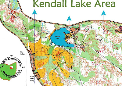
Online
photo albumThe North East Ohio Orienteering Club hosted a meet at the Cuyahoga Valley National Park, Kendall Lake area. The course was a "score" course, in which participants have 90 minutes to get as many "points" as possible. Points are obtained by finding flags in the woods, called "controls". Each control has points assigned to it (10, 15, 20, 25, 30, 35, 40) depending on its difficulty of distance from start point.
The organizers scheduled several mass starts at 12:15, 12:30, 12:45. At exactly noon, a steady rain began, which lasted over an hour. It was going to be a very wet course. The map given out was not of the same printing quality as the master map from which the controls were being copied/drawn from. Also, the control card was made of simple paper, and not waterproof. Many people used wide clear plastic packaging tape to protect the control card from the rain.
The score course had a total of 32 controls
pt
1 10 ruin, south-eastern most
2 10 rootstock
3 10 man made object in building setting
4 10 distinctive tree
5 15 boulder
6 15 hilltop
7 15 distinctive tree
8 10 eastern edge of vegetation
9 15 reentrant, upper part
10 15 boulder
11 20 reentrant, upper part
12 30 spur
13 40 knoll
14 20 rootstock, eastern most
15 20 trail intersection
16 20 boulder
17 30 stream bend, northern side
18 20 boulder
19 20 stream bend, southern side
20 20 spur
21 20 depression
22 25 rootstock
23 25 boulder
24 25 vegetation edge, northern edge
25 40 stream junction
26 30 stream junction
27 40 ruin
28 25 trail bend
29 35 distinctive tree
30 40 building
31 30 pond, western side
32 30 hilltop


12:30 mass start, in the rain a group of us takes off. Follow Randy, he's local and seems to know where to go, and we all punch at control 1 in a nearby ruin. Then up a trail going uphill. At a trail intersection with trail going north to 2, a trail going east to 4, and a trail going south to 3, all the participants seem to choose different routes. I see Randy darting uphill towards 4. I chose to go north for an easy find a control 2. Then, on my way towards 20, under the constant rain, the tall weeds and grasses of the marsh, realize how treacherous the running can be, even if map has it colored as white. With logs hidden under the grasses, running is practically impossible, and walk in long steps cautiously. Missed the spur where the control was, and after coasting the slopes with all the spurs, see the clearing up north and realize i must have passed it. Realizing that I just lost more than 10 minutes looking for a 20-pointer, and realizing that navigating and recognizing a spur among many possible parallel spurs can be very time consuming, decide to sacrifice it, and continue to the clearing, then to 21, and easy find. Go to the paved road north of it, and at the Ledges road intersection, take a compass bearing to go south for an easy find at 23, hidden nicely behind the big boulder. Gain uphill and to the clearing above, not runnable at all, but instead with grasses and weeds 3 meters high, and very slowly walk through some brush on the side to finally get to the dirt road just north of the clearing. Made a mistake in identifying the woods vegetation coming from south to north and when reaching the creek bed to the north, scouted the stream downstream, then back upstream in very slow and log-jammed conditions, to finally find 26. Retraced steps to reach the clearing to the south, then used the border of the clearing to find the lower clearing with the ticket with control 24. From there, reached the clearing SE corner, crossed the creek, climbed the spur, and followed the creek visually from staying high to then descend at the reentrant and easily found 25. Took a bearing to go south and crossed the area on map as difficult, but it wasn't too bad, and found the clearing with a chute shape towards West, recognized it, and found control 27 after a bit of map spotting. Got back to the clearing shaped like a chute, went to its western-most edge, descended on creek below and upslope later to get to the trail bend near control 18, recognized the reentrant, the control, back to trail, long run to 28. From there to 29, plan was to go west to trail. Somehow, I must have gone a bit too south, because when I did find a trail, and I saw it was next to a lake, I thought I was on the edge of Armington Pond. Instead, I was on a trail on the edge of the pond where the control was located. Went off the map several times, realized that I was at risk of getting lost, so retraced trail, reached the earth dam, and found control 29. From here to 30, had some trouble to find the clearing and trail, and went off the map, then retraced, found the trail, missed the buildings as reference, and continued until found the trail blocked by a gate and a large house with swimming pool and satellite dish. Looking for a building, but that building didn't seem kosher, so was ready to abbandon, and move on to another control, when, running back to pond, noticed the real building structures I had to look for, and realized I was back on true trail, and after a bit of confusion, since on the printed map the mapping feature looks like a boulder, but the clue sheet indicated a building, saw the building, can not seeing the control, I think, "it must be behind it", so ramp up the steep creek muddy slope for a final charge uphill, and once behind the small structure, no control. Look through a hole on the roof and see the control INSIDE. Small door entrance is on the northern side. From here to 31, see all that yellow on the map, indicating a clearing, but at this point, I was really wary of clearings, given the experience so far, might have un-runnable grasses and weeds. So, decided to stick to trails as much as possible, and went for a long but sure itinerary counterclockwise around Armington Pond, and found 31 easily. Then 32, easy find thanks to the bright shirt of another participant already at the site. 20 minutes left, gotta think of On-In. From there to 15, decide for trail, given the very thick underbrush, and go for a direct North to reach trail. Saw a fence, saw the fence on the map. Got on trail long run on gravel to 15. With less than 15 minutes left, thinking of going northerly direction to 16, 17, 4 (that would have given me 60 points). Get to a creek intersection, very deep gullies, actually, with log jams, and realize it was a time-sucker, and abandon attempt and return to easy gravel trail and follow it to large clearing to not-so-easy find on hilltop for control 6 (panic associated with end of time - mental mistakes..), then, remembering that NEOOC has a logarithmic scale on penalty time, realize I can afford to be a few minutes late, and went for 3, and returned to start, with a minute late. 418 points.
control found sequence:
1-2-(20)-21-23-26-24-25-27-18-28-29-30-31-32-15-(16)-6-3
in parenthesis, attempted but abbandoned
Instead of 2-20-21 (50 points total), should have gone for 4-5-19-22 (70 points) total. Instead of 16, should have gone for 14.
Route was about 9.6 km
A different
alternative route was 9.8 km

USGS Topo Map with route

Satellite image view with route

Swimming Pool found on trail

Randy's Route

Randy's route went for 1-3-6-8-10-11-13-12-7-9-14-15-16-32-31-30-29-28-18-27-25-24-23-22-19-5-4
scoring 620 points with 105 points in penalty for being 14 minutes late (1+2+3+..+14). Once at control 18, and with only 20 minutes left and 430 points so far, he realized that he went for the on-in, he would have only gotten 65 more points for finding 5-4-17-2. Instead, he went for a more fun route, going into over time, and to find 27-25-24-23-22-19, which alone this group was worth 175 points.
Retrospectively, if he really wanted to maximize on points, he could have just went for 27-25-24 (105 points), and then run back on the main trail to find 5-4 (maybe also 2 or 17), and with no time penalty, get a total 550 points. Good job Randy !


